Well, now that I learned how to take the train to Maastricht (last weekend) I decided to do a city walk in the Eastern half of the city. Like most people, I only went to the Old City Center (Centrum) in Maastricht. I have been there many, many times on this assignment and my previous assignment (1998-2001). My wife and I love the old part of the city. When you go online, the western side of Maastricht is just about all you read about. So I thought today would be a good day to take the train from Meersen to Maastricht and explore the "Wyck" area.

The area I am talking about is the walled in part of the city on the right side of this picture, the East Side of the River Maas, as shown in this drawing from 1750. The bridge shown here is Sint Servaasbrug, which still stands (though much of it has been rebuilt after WWII.). There is now a road that follows the inner (brown or tan) wall shown in this drawing and two bridges where the old wall met the river.
 I got off the train and walked out the front door of the train station. I wanted to first know how far it was from the train station to Sint Servaasbrug. This bridge crosses the Maas and puts you at the edge of the old city center; most peoples' destination. Well, once again there were antique venders along Stationstraat, the first 2-3 blocks of the route, and that slowed me down. I was also admiring the buildings, stopping to smell the baked goods at a bakery, and taking pictures. But otherwise, it would be a ten minute or less walk from the train station to the bridge.
 This picture shows a look back toward the train station (seen in the distance) from two blocks away. I really liked the character of these buildings and the split street. The street is split like this for three blocks, as Stationstraat, and then it merges to one street and is then called Wycker Brugstraat. This is strange because the bridge it leads to is Sint Servaasbrug. But there might have been a "Wyckerbrug" across the canal/moat back when it was a walled in city. That canal would have been where "Wilhelminasingel" is today.
I walked to Sint Servaasbrug and then decided to turn left and walk along the river front. I had never been to this area so I was just exploring. I'll use the map below as a color-coded reference during the rest of this blog.
 |
| Orientation Map |
The old, original part of the city is outlined in WHITE. I wandered around in there after walking along the river so I'll get back to that later.
 |
| Further up the river |
 |
| View from Sint Servaas Bridge |
 There are many interesting old buildings along the water front as well as restaurants and a few shops. Further along is a reconstructed (in 1897) section of the city wall showing a portal to the river. This was used by merchants and traders to bring supplies and goods into the city from the river. There would have been a dock and piers there in those days. It is bigger than this picture makes it look. Still further along, just past the Hoge Brug, is a reconstructed turret that was once used to guard the river. I failed to get a picture of that. Actually, there was so much graffiti and garbage there I just didn't want to take a picture. As a side note; I was saddened by the amount of trash and graffiti that I saw. Even churches have been vandalized. This is something you did not see when I was stationed in The Netherlands back in 1998-2001.
Going up river you'll come to the lovely "Charles Eyck Park" nestled between an apartment complex and the river. It is a small park filled with dozens of White (Paper Bark) Birch trees and one really weird statue. There are benches there so this would be a nice place for lunch or a snack in nicer weather. Charles Eyck was a well-know (at least in The Netherlands) artist who was born in Meersen in 1897 and died in Schimmert (my village) in 1983. You can view some of his works at THIS LINK.
As you continue along the river you will next come to the ultra-modern Bonnefantenmuseum. I have never been there but it is supposed to be a world class art museum.

 After the museum the route then takes you under the Kennedybrug (Kennedy Bridge) and just after that is a memorial dedicated to the US Soldiers of the 30th Infantry Division.
 The next thing to see is the Provincie Limburg Gouvernement building. The path actually goes under some of the building. This complex is shown in blue on the orientation map. This building complex houses the provincial government offices. There is a good pamphlet that describes the history and functions of the "Gouvernement" (and yes, that is spelled correctly) at this LINK. This will open an English language .pdf file. I learned quite a bit reading this.
 The end of the riverside walk is after the Gouvernement building and where the "Kleine Weerd" begins. In the photo here you can see the gouvernement complex on the island and below that is the Kleine Weerd. The Kleine Weerd is a 29.6 acre nature reserve. This is shown in green on the orientation map.You are allowed to walk around but are warned to keep your distance from the wild horses that live and graze in the reserve. In warmer months it is supposed to be full of wild flowers and flowering bushes. From where the wide part of the waterway is, if you look off in the distance you can see Fort Sint Pieter. This is shown circled in yellow on the orientation map.
 I didn't want to go further out of the city so I walked up to the main road and then turned left and walked on the bike/pedestrian path back toward the city. You'll pass in front of the Limburg Gouvernement building complex. This walk then leaps you forward two hundreds years as you walk through the "Cèramique" area. I show this area circled in red on the orientation map. This area is a large neighborhood of modern apartments, offices, shops, and restaurant buildings. It is very integrated so it must have all been built at one time. Every building has outdoor open space and lots and lots of windows to let in natural light. I don't normally care much for the modern look but this area was impressive.
 The path will eventually take you back to the "Wyck" area and then you can explore the shops, architecture, and eating establishments. There are blocks of buildings from the early to mid-1700's, like those on the right side of this street. I didn't spend much time looking in the shops but there is everything from antiques to "Coffie Shops" for potheads.
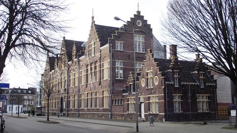 There are other blocks further north and closer to the train station that are lovely examples of turn-of-the-century styles. Those buildings were mostly built between 1880 and 1910 +/-. This building (left) was once a Trades or Technical School and was built in 1911. I love the brickwork and the decorative coloring. It is now an office complex.
 After I wandered around the Wyck for about two hours I headed back to the train station to head home. Now we all know that there are a lot of bikes in The Netherlands but you really get an appreciation for that when you walk around the outside of a train station. There must be thousands of bikes in these racks. I know that some of my co-workers have two "commuting" bikes; one at each end of their train ride. They ride a bike from home to the train station and lock up one bike. When they reach the destination train station they hop on their second bike and ride it to work.
I got on the train and headed back to Meersen and my trip was done. It was cold and a little dark, as you can tell from the pictures, but still a nice day out (and very cheap).
No comments:
Post a Comment